Winter means rain, snow and storm for all. Especially countries close to North Pole have nearly 5 months of hard winter every year. While winter storms last for one day mostly, northern storms can continue for 4 or 5 days. Some snow storms can also cause big havoc. All winter storm types have some signs and it can be vital to understand what type of winter storm is coming and how it can last. How many winter storm types are there?
Main winter storm types are Blizzards, Ice Storms, Upsloping, Overrunning, Lake Effect, Eastern Rockies, Nor’Easters, Eastern Rockies and Pacific Coast Winters.
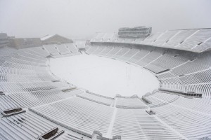
Blizzards are known with low temperature and strong winds. In Blizzards, temperature is generally under 20°F. Also wind speed is 35 mph or greater. Blizzards are characteristics with blowing snow. Most important effect of Blizzards is lack of visibility. In standard blizzards, visibility can reduce to 1/4 mile. Blizzards last at least 3 or 4 hours. Also lower pressure and higher pressure differences create strong winds. Also when atmospheric temperatures low enough, it can cause freezing rain. Most known Blizzard storm season was 96-97 in Minnesota. Also Canada and Gulf of Mexico are very vulnerable for blizzards.
Eastern Rockies are very common in United States. It causes very cold air and snow. It was Silver Lake, Colorado that broke the record in April 14 and 15, 1921 where 76 inches of snow fell. Winter storms like Eastern Rockies need strong areas of low pressure. Also it creates strong winds.
Great Plains snow storms are common in Texas and close areas. Great Plains start with strong cold wind. Temperature drops significantly. It’s characteristic with blue-black sky which is known as “blue norther” Most famous moment of Great Plains was Thanksgiving Day, 1993. There was a Dallas Cowboys match and it stopped because of Great Plains snow storm.

Ice Storms in US occur when low pressure moves to Gulf of Mexico. Many countries like Mississippi, Alabama and Georgia affect from Ice Storm. It’s very rare to see ice storms stop the life in cities but in 1973, ice storms hit the Alabama area and left four inches of ice. Ice storm left over 300,000 people without power.
Lake Effect winter storms occur when cold air went over warmer water. This move creates an unstable temperature condition in atmosphere. After this move, clouds create a lake of snow in the air. Snow falls to earth as a mixture of snow and ice. It’s possible to see Lake effect winter storms in some local areas close to North Pole. When it’s started in local areas, it creates an Arctic air effect and hits the life. Clouds leave large amount of snow and very cold air into area. Areas like West Virginia and Great Salt Lake in Utah are possible places to see lake effect winter storms. Most known lake effect snow storm was in Cape Cod Bay in Massachusetts.
Many people believe that Nor’easters are the strongest winter storms in the US. Low and high pressure areas coming from Gulf of Mexico and Atlantic Ocean clashes and creates storm. Boston and New York City are the main areas to see Nor’easters. It starts with rain and suddenly turns to strong winds and snow. It carries all strong northeasterly winds from ocean to areas. Most known Nor’easters storms are “The Ash Wednesday Storm” in 1962 and February 1979 Presidents Day Storm.
Overrunning winter storms are a clash of polar air and tropical air. It creates a huge unstable weather condition. Also there are Pacific Coast Winters and Upsloping winter storms.